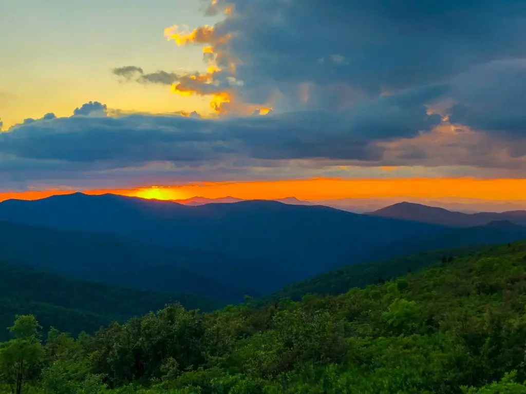
As the sun set over Shining Rock Wilderness in Western North Carolina, the mountains turned all shades of blue, pink, and purple. Mount Pisgah — the 5,700-foot peak that towers over Asheville — looked so small, so far below me, from my campsite. The wind was brisk, the temperature cratering, the iconic ‘”smoky” clouds rolling in, but I didn’t care. This was exactly why I went hiking the Art Loeb Trail.
The Art Loeb is one of the most beautiful — and most challenging — backpacking trails in the Southeast United States. It attracts avid hikers, people training for Appalachian Trail thru-hikes, and even ultra runners (who run the entire thing in one day). I hiked it over a long weekend in June 2020. In this post, I’ll share all my insider tips as an Asheville local to help you plan the perfect weekend in the woods. Whether you’re in the early stages of planning or getting ready to hit the trails, read on for all the details you need!
Note: This post contains affiliate links. If you decide to purchase through these links, I receive a percentage of the sale at no additional cost to you.
Hiking the Art Loeb Trail: The basics

The Art Loeb Trail runs 31 miles from Davidson River Campground in Brevard to Daniel Boone Boy Scout Camp at the base of Cold Mountain (yes, that one). Along the way it passes through Pisgah National Forest as well as Shining Rock Wilderness. It traverses four 6,000-foot peaks and about six miles of ridgeline where you’ll get views of many more, and covers 9,000 feet of elevation change.
The trail was named after a Carolina Mountain Club member who loved these mountains. It opened in the ’60’s and has been the pride of the WNC region ever since. Ask any Ashevillian where to go hiking and we’ll tell you to do the Art Loeb.
One thing that makes hiking the Art Loeb Trail challenging is that it’s a point-to-point hike. That makes transportation difficult, which, on the plus side, keeps the crowds way down. Aside from a short, crowded segment near the Blue Ridge Parkway I encountered only four other groups along the entire trail (and they were all going the other way).
The trail is divided into four segments, which locals use for day hikes. Section 1 runs 12.3 miles from Davidson River to Gloucester Gap. Section 2 — the most difficult — continues to Black Balsam Knob over a brutally steep 7.2 miles. Section 3 is the most beautiful, and the easiest, running a mostly flat 6.8 miles — almost all above 6,000 feet with 360-degree views — to Deep Gap. The final section descends 3.8 miles down Cold Mountain.
The sections are useful to orient yourself, but you don’t have to break up your trip according to them. I hiked about 2/3 of Section 1 on my first afternoon, then got all the way to the end of Section 2 on my second day, and finished the remainder of the trail on Day 3.
How fit do you need to be to backpack the Art Loeb Trail?

Okay, so the Carolina mountains aren’t the Rockies or the Sierras. If you regularly backpack in high-altitude terrain, you’ll probably be able to hike the Art Loeb with minimal effort. But for most visitors and locals in Western North Carolina, the trail is a formidable challenge that you should prepare for. I found hiking the Art Loeb Trail to be more challenging than the 14-day trek I did in Nepal.
The key factor when deciding how fit you need to be is the elevation gain. 9,000 feet in three days is no joke, especially not with 40 pounds on your back. Two extremely challenging sections are the climb up Pilot Mountain and the final ascent to Black Balsam Knob — and many hikers have to tackle them both on the same day.
Additionally, unlike on the West Coast, it’s hard to pack ultralight for the Art Loeb because you must carry a bear canister. This adds about 3 pounds to your pack, and it doesn’t get any lighter when you eat all the food. You also have to carry 4 liters of water for about half the trek because water sources are scarce in the middle of the trail.
In the weeks before I went on my backpacking trip, I trained regularly. I hiked gradually increasing distances, starting at 7 miles at a time, with my fully packed backpack, once a week. Then I increased to twice a week. I knew I was ready after completing two days of 12+ miles in a row with my backpack on. I found it to be a difficult hike, but not outside my ability level.
If you’re less fit, you may still be able to backpack the Art Loeb — but I’d highly recommend doing it north-south, which cuts a couple thousand feet off the elevation gain and allows you to descend the two steepest sections. It’s not a great idea to strap 40 pounds on your back the first time you hit the trails.
How long does it take?

The average amount of time backpackers spend on the Art Loeb Trail is 3-5 days. Where you land in that range will depend on your fitness level, which direction you’re hiking in, and how much time you want to spend hiking vs. at camp.
At the low end, it is possible to hike the whole trail in a weekend. If you want to attempt it, you’ll need to camp near the trailhead on Friday night — if you don’t even drive out until Saturday morning, you won’t have enough daylight hours to hike. I wouldn’t really suggest trying to cram the hike into two days though — you will miss the best camping spot (Black Balsam Knob), since you’ll reach it too early on Day 1 to stop for the night.
For a fit hiker, 2.5 days is the ideal amount of time. This is what I did. My itinerary was:
- Friday 1 pm: Start hiking from Davidson River
- Friday 5:30 pm: Set up camp below Cedar Knob (8.5 miles)
- Saturday 8 am: Start hiking
- Saturday 6:30 pm: Set up camp on Black Balsam Knob (12.5 miles, but I also wandered around Black Balsam for awhile trying to find the perfect campsite. I really finished hiking around 5:45 pm.)
- Sunday 8 am: Start hiking
- Sunday 2 pm: Arrive at Camp Daniel Boone (9-ish miles). I practically ran down Cold Mountain due to an impending thunderstorm though — the last 3.7 miles took me under an hour, which my knees and ankles did not appreciate.
If I had to do it again with a little more time, I’d break up the second day at Deep Gap (the one below Pilot Mountain). That would’ve saved me from the double-whammy climb up Pilot Mountain and Black Balsam Knob in the same afternoon. And since Deep Gap has the only water source in the middle 15 miles of trail, it’s an ideal camping spot.
If you have a full five days, and you don’t mind spending more time at camp, the campsites around Shining Rock and Ivestor Gap are incredible. Just be careful of bears (more on this below).
Which direction should you hike in?

Because it’s a point-to-point trail, you have the option of hiking the Art Loeb Trail in either direction. The big factors to consider are difficulty, where you want to camp, water sources and transportation.
The vast majority of hikers go from north to south (starting at Camp Daniel Boone and ending at Davidson River). I went south-north. There are pros and cons of each.
Factors to consider if hiking the Art Loeb Trail from north-south:
- The elevation gain is around 7,000 feet. This is the easier direction (but still no joke).
- Your first day involves 4 miles of climbing up Cold Mountain. It’s not steep, but it is the longest climb in either direction.
- You will have to descend the two steepest sections of the trail — not great if you have bad knees.
- The descent of Black Balsam can be really dangerous/slippery if it’s rained recently.
- All the great views will be on your first day.
- If you can’t get as far as you hoped on your first day, you’ll have to camp in prime bear territory.
- More convenient bail-out points earlier in the trail.
- Better-spaced water sources.
- If you want to camp on Black Balsam, you’ll need to get 10 miles in on Day 1 — or break it into two very short days.
- There’s a lot more/safer parking at Davidson River Campground.
- When you finish, you’ll be a 2-mile drive from BiLo (a grocery store with clean public restrooms and all the food you can stuff your face with).
Factors to consider if hiking south-north:
- The elevation gain is 9,000 feet — almost all of it on Day 2.
- The first and last days are easy.
- You have to climb both Pilot Mountain and Black Balsam Knob in the steeper direction. It’s brutal.
- You’ll save the views for the end.
- Because it’s mostly downhill on your last day, you can easily avoid camping near Shining Rock Gap and its aggressive bears.
- Once you pass Butter Gap, you don’t really have a choice but to climb all the way up to the Parkway. No good bail-out points in between.
- You’ll have to climb for half a day, plus cook, using water from the sad water source at Deep Gap. (In other words: You WILL run out of water.)
- The parking at Camp Daniel Boone sucks. My car almost ended up in the river.
- Camp Daniel Boone is in the middle of nowhere and has no cell service — it’s a long drive back to Asheville when you’ll be exhausted.
If you’re looking at this list and neither stands out as a clear winner, I’d say go south-north. Saving the views for your last day gives your trek more of a sense of journey, and helps keep your energy up when you don’t feel like walking anymore. But if you’re at all concerned about your fitness, north-south is the clear way to go.
What time of year is best? What’s the weather like?

You can technically hike the Art Loeb Trail year-round, if you have suitable camping gear. Both trailheads are accessible in the winter (and I bet camping on Black Balsam would be incredible when the Parkway is closed).
Western North Carolina has a mild climate, even though it’s in the Southeast. The heat and humidity you associate with NC doesn’t make it up to the mountains. In fact, chilly nights are a bigger problem than melting during the day.
Autumn would be a beautiful time to backpack this trail — the leaves changing would only add to the spectacular views. But personally, I’m partial to late spring. The wildflower blooms are incredible above 5,000 feet — mountain laurels at lower elevations, and the most incredible pink rhododendrons on the peaks (mid-June is best for these). Plus, spring gives you lots of daylight hours.
At any time of year, expect torrential downpours in the afternoons, and the possibility of steady rainfall all day. WNC is one of the most spectacularly green places on the planet — but it gets that way because it rains a lot. Also be mindful of fog rolling in from out of nowhere and totally obscuring the trail, especially in Shining Rock.
If you plan to camp on Black Balsam Knob, spending the night on an exposed bald at 6,000 feet requires some special planning. It will be a good 20 degrees colder up there than in Asheville (in mid-June it was 40 degrees overnight). It will be windy and wet, even if it’s not raining. You’ll need a completely waterproof tent and you really do need to stake it down. If you go between October and May, you have a chance of getting snowed on. And don’t even think about pitching your tent on the bald if there’s lightning in the forecast — camp in the evergreen forest just before the summit instead (it’s a 5-minute walk to the sunset viewpoint).
What’s the trail like? What type of scenery will you encounter?

One of the best things about hiking the Art Loeb Trail is you get to see a huge array of the biodiversity the Carolina mountains are so famous for. The nearby Great Smoky Mountains are the most ecologically diverse national park in the U.S. — and you’re essentially in the same ecosystem, just a few miles further east.
Whichever end of the trail you start at, most of your first day will be spent in the ‘green tunnel’. You’ll climb through dense rainforest and balsam forest. The vegetation is thick and very, very green. Water is plentiful. You’ll see lots of small wildflowers. One of the great joys of backpacking in this area is waking up to the sounds of dozens of bird species in the lower elevations near Butter Gap.
You don’t really get above the treeline until you reach Graveyard Ridge/Black Balsam (even though you cross several 5,000-foot peaks before that). The change in scenery is dramatic — craggy peaks, short grass, shrubbery and rhododendrons. The trail is a lot rockier, but you won’t mind. You’ll be more focused on the panoramic views of Shining Rock from all sides before you descend once again through the green tunnel.
Trail Conditions and Navigation
The entire trail is well-maintained but narrow. This gets dramatically worse in Shining Rock, where you’ll often have thorny shrubs grabbing at you from both sides. If you have concerns about COVID-19 transmission, I would suggest hiking this section on a less-crowded weekday — between Ivestor Gap and Shining Rock Gap, there is nowhere to step off the trail to let people pass with six feet of distance.
Additionally, the ridgeline from Stairs Mountain to the turnoff on the Cold Mountain Trail is pretty dodgy. It’s somewhat of a rock scramble on a very steep pinnacle. Side trails provide the illusion of easier routes until they run into sheer boulders that you have to scale to get back to the main trail. Pack up your hiking poles so you have free use of your hands in this area. The scramble up the quartz boulders at the Shining Rock Summit is similar.
The trail is very well-marked throughout the Pisgah Ranger District (Davidson River to Black Balsam Knob). It uses white blazes, and a clear signpost points you in the right direction at every intersection.
That all changes when you get to Shining Rock Wilderness. Shining Rock has no marked trails and dozens of small side trails. Do not — I repeat, do not even think about — hiking in Shining Rock without a paper map, a compass, and solid knowledge about how to navigate with them. I hike in this area regularly and I still lost the Art Loeb at an unmarked six-trail intersection near Ivestor Gap. (I had a paper map but I also knew what the next summit I was shooting for looked like from prior experience in the area — I took a spur trail but it added about a mile to my hike.) The turnoff to the Cold Mountain Trail is another exceptionally confusing spot.
Where can you camp while hiking the Art Loeb Trail?

Camping is allowed anywhere in Shining Rock Wilderness and Pisgah National Forest, as long as you’re at least 1,000 feet from a road.
Whenever you’re camping in the backcountry, it’s important to follow Leave No Trace Principles. That includes trying to use already-established campsites rather than creating a new one. Except at the very beginning and end, you never have to walk more than about half a mile on the Art Loeb Trail before finding an open campsite.
Additionally, Pisgah and Shining Rock have strict rules on the use of fires. In Shining Rock they’re prohibited entirely (although you’ll still see some folks using the giant fire pit on Black Balsam Knob), and in Pisgah they’re often banned during wildfire season. Bring a camp stove instead of relying on fires for cooking.
The #1 place everybody hiking the Art Loeb Trail wants to camp is between Black Balsam Knob and Tennett Mountain. It’s the best sunset view in Southern Appalachia — 360 degrees from 6,000 feet. It is absolutely magical and you should plan your entire hike around it — but, bear in mind that you’ll only be a mile from the Parkway here. Lots of casual campers park near the trail and walk in with full car-camping gear. It’s very crowded and you need to get here early to find a good spot. Tennett Mountain is a lot quieter than Black Balsam Knob.
Other good options include the string of campsites below Cedar Knob, Butter Gap Shelter, and Deep Gap Shelter. These are very quiet areas and all have good access to water sources.
The one area to avoid is Shining Rock Gap. This area is infamous for aggressive bears. There are some beautiful campsites just below Shining Rock Mountain, but you’re better off continuing to Ivestor Gap to avoid battling wildlife for your dinner.
Where can you find water on the Art Loeb?

Surprisingly for Western North Carolina, the Art Loeb Trail is short on good water sources. The beginning and end of the trail have plentiful water, but once you’re up on the ridgeline, you only have two chances to fill up. Be ready to carry 4L.
Starting from Davidson River, you’ll pass a bunch of small streams on your first day. The first proper water source is the pipe-fed stream at Butter Gap. Fill up as much as you can here — it’s the last really good option for almost 15 miles.
Next, you’ll come to a small stream at Deep Gap Shelter. Facing the shelter, take one of the paths to your right and look for a place where the stream is deep enough to fill your water bottle. It isn’t much, and sediment is an issue, but you absolutely must fill up as much as you can. You have to carry enough water for the biggest climb of your hike, cooking two meals, and another 3+ miles the next day. I carried 3L and I still ran out.
Theoretically, there’s a water source somewhere near Ivestor Gap — but it’s about half a mile off-trail. I read about it in a bunch of guides beforehand but I couldn’t find it on the AllTrails map, and none of the other folks I met hiking in the area could find it either. You’re close enough to Shining Rock (and better water) at this point that it isn’t worth hunting for. (Update August 2020: I found the water source near Black Balsam! It’s quite a bit off-trail though. You need to go to the main Black Balsam parking lot, walk toward the restrooms (so they’re on your right), and pick up the trail leaving the parking lot along Black Balsam Road. You’ll find the river about a tenth of a mile in. From the Art Loeb, it’s about a mile out-and-back for water, but that would’ve been worth it to me in retrospect.)
Shining Rock Gap has your next reliable water source. You’ll pass a wooden sign to Big East Fork on your right. Keep your ears open — the very short side trail to the piped water source is about 100 yards past that sign.
Finally, you’ll have plenty of options for a final refill on your way down Cold Mountain.
Where are the bail-out points if you get hurt or need to quit?

While the Art Loeb Trail is long and feels very wild most of the way, it also intersects a number of major roads. If you get hurt or just don’t want to continue, it’s pretty easy to find a bail-out point within a few miles. Here are the main ones:
- Mile 6: Cat Gap Trail will take you to the Pisgah Ranger Station
- Mile 9: Just past Butter Gap Shelter, the Butter Gap Trail will take you to the Pisgah Ranger Station
- Between Mile 11 and the base of Pilot Mountain, you’ll cross a couple gravel roads. The one below Pilot Mountain is high-traffic (lots of people day-hike here) and you could easily hitch a ride back to Davidson River.
- Right before climbing up to Black Balsam Knob, you’ll cross the Blue Ridge Parkway.
- From Black Balsam Knob, you can walk one mile on a flat trail to the visitor center on the Parkway. There are restrooms, good cell service, and lots of traffic — easy to get help if you need to.
- Between Black Balsam Knob and Graveyard Ridge, a number of bail-out points will take you back to the Parkway. I only recommend using them in an emergency and if you have a good paper map and compass, since none of the trails are marked. The Ivestor Gap Trail is the easiest one to walk on if you have a foot/ankle/leg injury.
- Just before Shining Rock Gap, the Big East Fork trail will take you 3.5 miles straight down to Route 276 and a big parking lot. No cell service but plenty of cars from which you could easily hitch the 2 miles to the Parkway.
Bears on the Art Loeb: How to handle a bear encounter

The biggest wildlife threat on the Art Loeb Trail is black bears. They are prevalent along the entire trail, aggressive in the Shining Rock Gap area, and of most concern in the early spring (cubs) and the fall (stocking up on food before hibernation).
Your best defense with black bears is to scare them away before they get anywhere near you. Make lots of noise as you hike — talk with your hiking partners, or if you’re alone, sing to yourself. Commercial bear bells aren’t loud enough to make any difference.
If you see a bear from a distance, stop and let it pass — or walk around it if you can stay at least 100 yards away. Hopefully it won’t so much as notice you.
In the event that it does notice you, the bear is more likely to be scared than to be aggressive. Back away slowly and the bear will likely move along. If it seems interested in you, back away slowly while making yourself look as big and loud as possible. Shout, raise your trekking poles above your head, etc. One hiker friend swears by carrying an air horn for this purpose.
Black bears rarely attack people. But if you get really unlucky and start to see evidence of a charge (ears back, teeth bared), your only option is to fight back. This is where bear spray comes in handy. Some hikers have also had luck throwing rocks or sticks. Do not play dead with black bears.
The highest chance of an unpleasant bear encounter is at your campsite. You can mitigate the risk by avoiding camping in Shining Rock Gap. But if a bear does decide to investigate your dinner, bang pots and pans together and follow the steps above to make noise. Do not share your food with the bear — this only trains the bear to expect food from humans.
Never, ever, ever store food or anything with an odor (soap, toothpaste, etc.) in your tent. Lock it all in your bear canister and store your bear canister at least 70 large steps away from your campsite (pro tip — store it upside down so water doesn’t leak in). You can find more details about how to use a bear canister here. Additionally, don’t cook near your tent. Set up your camp kitchen at least 70 large steps away from both your bear canister and your tent, and always downwind of your tent.
How to get to the trailheads

Because the Art Loeb Trail is a point-to-point hike, you’ll need to either take two cars or use a commercial shuttle service. No public transport runs to either trailhead.
Camp Daniel Boone is about an hour from Asheville, in the back roads outside Canton, NC. It’s really out in the middle of nowhere. When you arrive at the camp, drive past the reception area until you reach an area where you’ll see cars parked along the side of the road. This small area is the parking for the Art Loeb and Cold Mountain trails. The trail is on the left, clearly marked.
Davidson River Campground is a lot more convenient — it’s off 276 less than a mile from Brevard. You can get here in about 45 minutes from Asheville (more like 30 minutes if you rent a car from the airport). Brevard has lots of outdoor stores where you can pick up camp fuel or other things you couldn’t travel with.
Driving between Davidson River and Camp Daniel Boone takes about an hour and a half. On summer weekends, it can be even longer due to traffic in Pisgah.
Since I hiked the Art Loeb alone, I used a commercial shuttle service. I booked with Pura Vida Adventures and they were great. There are cheaper options, but they have less flexibility with timing and it’s hard to coordinate a north-south shuttle.
What to pack for hiking the Art Loeb Trail

Your packing list for hiking the Art Loeb Trail is the same as any other backcountry camping trip. Below is my gear list.
To carry it all, I use this incredible women’s backpack. I know, I know, it’s not an Osprey. But it has this really cool technology that makes the pack feel like it moves with you — rather than it shifting its weight as you move, it keeps you centered. Trust me when I say you will appreciate that feature when you are rock scrambling along the ridge on the other side of Shining Rock Gap.
Clothing
- One short-sleeved merino wool shirt
- One merino wool fleece
- One pair of hiking pants
- One sports bra
- One pair of quick-drying underwear per day on the trail
- One pair of merino wool socks per day on the trail
- One pair of leggings to sleep in
- One long-sleeved shirt to sleep in
- Flip-flops to wear at camp
- Hiking boots or trail runners (I’d stick with boots for the Art Loeb due to the uneven trail conditions)
- Trekking poles
Camping gear
- One-person weatherproof North Face tent
- Sleeping bag rated to 30 degrees F for women
- Sleep sheet
- Inflatable pillow
- Lightweight tarp
- Sleeping pad
- Headlamp
- Small backpacking trowel
- Multi-tool
Camp kitchen
- MSR Pocket Rocket stove and cook kit
- Small canister of fuel
- Lighter and matches (always bring backups!)
- Steri Pen for water purification, plus iodine tablets as backups
- Bear canister
- 2 dinners: I like Mountain House dehydrated meals, especially the pasta primavera
- 2 breakfasts: I like instant oatmeal with some dried fruit and nuts added. I also pack gourmet instant coffee from my favorite local coffee shop, because fancy coffee in the backcountry is the one luxury I can’t give up.
- 3 lunches: I packed everything bagels, spreadable cheese, and pepperoni.
- Snacks: Trail mix, dried mangoes, dried apricots, granola bars, protein bars, fig bars, sesame sticks. You are going to burn an unbelievable number of calories — don’t skimp on the snacks!
Miscellaneous
- Camp towel
- Toothpaste, toothbrush, contact lens solution
- Wet wipes
- Backcountry-friendly dish soap
- Toilet paper
- Tissues
- A couple of garbage bags
- Sunscreen
- Hand sanitizer
- 3L water bladder, plus 1L water bottle you can use to purify and refill
Overall, the Art Loeb Trail was one of the best hikes I’ve ever done. Feel free to leave me a comment if you’re planning a trip to my beautiful home of Western North Carolina — I’m happy to share more local tips!
Like this post? Pin it!

I’ve backpacked in Shining Rock but don’t know this trail so it was great to get such a detailed guide to a beautiful area. The photos are stunning.
Ooo where else did you backpack in Shining Rock? I’ve done a few offshoots of the Art Loeb and loops to Graveyard Fields, and done a bunch of day hikes in the Big East Fork/Pigeon River area, but I’ve barely started exploring the deeper backcountry there.
Omg if I ever saw a beer during hiking, I will afraid to death. I have never done days of hiking. But it sounds interesting.
Haha I felt that way at first! When I moved here I was too afraid to hike alone because I didn’t know what to do if I found a bear. But then I did a little walk in a park in my neighborhood and ran into a whole family of bears 10 meters away — and they totally ignored me! That gave me a lot more confidence for more serious hikes.
What a sunning trail! It is crazy that you saw so few people when the views are that gorgeous! Woooowza!
I like that the hardest day is in the middle…just as you are getting used to carrying the extra weight! Then you get to finish on an easier day again. 🙂
Exactly! I’m always ready to be done about 3 miles before reaching my car (when I start fantasizing about the hot shower waiting for me), so I definitely prefer those last few miles to be downhill.
Such a thorough guide! I would love to hike some of the mountains in the South. I will definitely save this article for later.
Thanks Kelli! I hope you get a chance to hike here in NC someday — for my money, it’s every bit as beautiful as the western U.S.
We lived in hills about lake Tahoe for a while, and there were bears there too. Thankfully, I never encountered one on the trail, although they had been known to be in the neighbourhood rubbish bins. This sounds like a fabulous hike, and the detail here seems to cover it all.
Ah, yeah, bears in the rubbish bins are a major nuisance here too!
Love this, and those colors in the sky look gorgeous. I’m trying to do more backpacking adventures, will add this to the list when I make my way back east!
I hope you get a chance to visit WNC someday!
Just moved to North Carolina and did our first foray into the mountains this weekend, we are excited to explore a bunch more, this spot is unknown to me and I look forward to checking it out!
Oh awesome! Where did you move to? I’m so excited for you to explore the mountains more — feel free to reach out anytime if you want tips for great hidden spots :).
Thank you. This is all great information!
Thanks Jason — I hope you have a good hike!
Thank you for all the info. I’m planning to go in a few weeks. Reading through your post has me even more excited!
How are the campsites after Shining Rock Gap? Any worth setting up camp? We were going to try and avoid Shining Rock Gap area because of the bears. We had some bears huffing/snorting through our campsite in the middle of the night in Colorado this past summer, and that was enough for me.
Which direction are you hiking in? If you’re going south-north: I’d recommend camping before Shining Rock on either black Balsam or Tennent mountain, and then knocking out the last 10 miles on your last day. But if you really don’t want to camp there, the next-best option is on/near Flower Knob — there are some very pretty campsites there that should be fairly safe from bears. Once you pass Shining Rock summit, you could go all the way to near the summit of Cold Mountain — it’ll take you off the Art Loeb, but there are some lovely and bear-safe… Read more »
What would you say is the best places to camp on this trail? Where are the water fill ups? My husband is wanting end the trail at the Davidson River Campground so we can shower and camp before we head to the airport. We plan on hiking this in 3 days.
Also, is there any AT&T cell reception on the trail? Thanks so much! This was one of the best articles I’ve read!
Hi Lindsey, sure thing, so happy to hear you’re going to hike the Art Loeb! Re: cell reception — definitely not. Pisgah National Forest and Shining Rock Wilderness are completely out of range, even when you cross the Blue Ridge Parkway. The #1 place to camp is on Graveyard Ridge somewhere between Grassy Cove Top and Black Balsam Knob. You have TONS of options there, with some pro’s/cons. Personally I like Black Balsam despite the crowds: – Ivestor Gap: Amazing views in the gap itself, but there are bear issues – The climb up to Tennent Mtn: Beautiful high-elevation balsam… Read more »
I haven’t heard of this hiking trail before but the views you get from it are amazing! Definitely one for my hiking bucket list.
yeah, it’s still pretty off the beaten path except for locals in North Carolina! Luckily that keeps the crowds down.
Carrie, do you know if there is any parking at the Parkway for a north to south half trail trip?
There is – kind of. You’d want to park at Fetterbush Overlook. From there it’s a 0.5 mile road-walk to where the Art Loeb crosses.
But honestly the climb up Silvermine Bald suuuucks. So if you’re doing the Shining Rock segment, I’d recommend parking at Black Balsam Knob and picking up the Art Loeb from there. If you’re doing the Pisgah Ranger District segment your best bet is to park at Gloucester Gap and hike from there to Davidson River.
Thank you so much for the information! The Art Loeb Trail is next on my list to hike, and this article is extremely helpful!
Yay, I hope you get a chance to hike soon!
Hi Carrie- Very informative article! My niece is doing the Art Loeb trail from south to north. We are a one car household so I will be dropping her off. She does not know how long it will take her. How far from the boy scout camp will she need to hike in order to find cell phone service? Thanks- Susan
Sorry I didn’t see this earlier! For others who see this comment — I wouldn’t count on getting cell service anywhere near walking distance of Camp Daniel Boone. It’s in a quiet back-corner of Canton, down a country road that connects to another country road — I usually have to drive 20 mins before I get reliable service.
First of all, as a single woman until the age of 37, I celebrate your independence. Second of all, as a 40 year old married woman, I celebrate your independence. I am fortunate enough to be married to a man who encourages doing things independently as much as together. I’m about to hit up the Art Loeb with a girlfriend. Planning on N to S over 4(ish) days with plans to hit up Cold Mountain and Shining Rock shooter trails.
I am hoping to do a another solo trip soon and looking at NC 50ish mile trips .
Nice! Have fun on the Art Loeb :). The Cheoah/Wesser Bald Loop in Nantahala is an awesome 58-miler too!
Great article!!
FYI. I hiked a section of the ALT this weekend from Deep Gap to Butter Gap and found a piped spring near Gloucester Gap intersection with forest service road 475. It is 300 yds off trail going north on FS475. Also a beautiful waterfall a little further.
Thanks for flagging! Yeah there’s some seasonal springs off 475, but they aren’t all drought-resistant. Always worth checking, but I wouldn’t recommend relying on them between June and November.
Hi Carrie!
I am heading out this weekend to complete the Art Loeb (solo hiking). I will be traveling northbound and plan to complete the 30+ mi in 2 days. Looks like there might be some isolated thunderstorms so I am not sure if I should plan to hike up to sleep on any of the balds. There is a campsite around 15.6 mi (per AllTrails). Any suggestions?
Hi Haley, so sorry I’m just seeing your comment now! Seems like the storms are going to blow through before dark – I’d definitely stay off Graveyard Ridge (between the Parkway road crossing and Cold Mountain) while it’s storming, but you’re probably good to camp up there tomorrow night. If it’s looking iffy, camp on Black Balsam because you can easily retreat off the bald into the pine forest (or down to the restrooms) in an emergency.
Hey Carrier – is your AllTrails recording accessible so we could literally FOLLOW it?
Here’s one you could follow: https://www.alltrails.com/explore/recording/evening-hike-at-art-loeb-trail-376d41c?u=i. It looks like they started somewhere along the road instead of at the true southern terminus (which is pretty common when parking at Davidson River is a nightmare), but you can clearly see where the campground — the ideal starting point — is. Happy hiking!